
BATON ROUGE, La.—After Hurricane Ida slammed into the Louisiana coast in August 2021, it took more than 100 lives and cost billions of dollars in damage. To some here, the storm was just one more justification for a desperate measure to preserve the coast by intentionally flooding parts of the state.
“I don’t mean to be alarmist about it, but anybody who’s spent any time along our coast, whether you’re fishing, hunting or working, you’ve seen the changes to our coast. We know it’s going away,” says Bren Haase, executive director of the state’s Coastal Protection and Restoration Authority (CPRA). “I don’t think we can be successful without using the tools and the resources in the Mississippi River to help restore our coast.”
On average, between 1985 and 2010, Louisiana lost about a football field of coastline per hour, and the rate has not slowed. Stronger storms each year and sustained sea-level rise continue to eat away at its coast. Few have felt these effects more than the coastal communities. Hurricane Ida forced most of the remaining members the Biloxi-Chitimacha-Choctaw tribe to abandon their homes on Isle de Jean Charles.
The storm also destroyed 68 out of 80 homes in Pointe-aux-Chenes, an Indigenous community along the Gulf of Mexico in Louisiana. “I’ve never seen anything like it in all my life,” says Theresa Dardar, age 65. It took the state more than two months to bring water and electricity back to the community.
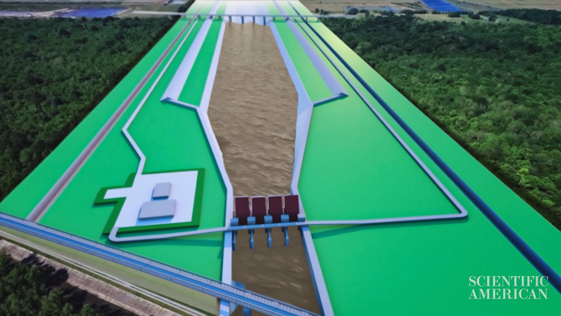
The state is now proposing a $2-billion plan, called the Mid-Barataria Sediment Diversion project, that would allow the river to flood the Mid-Barataria basin at certain times throughout the year. These controlled floods could, over 50 years, regrow up to 36 square miles of land in the Barataria basin, according to Haase.
But in a situation where the invasion of water is the problem, how could the solution possibly be more water?
Before the Mississippi River levee system was built, the river flowed unrestrained, often flooding large parts of Louisiana. But the floodwaters also brought in sediment important to preserving the integrity of the coastal marshlands. Once the river was restricted by the Army Corps of Engineers’ network of levees after the Great Flood of 1927, the wetlands lost much of their supply of sediment and began to erode.
When Hurricane Katrina hit, exactly 16 years before Ida made its own landfall, those levees were a big part of the problem. Floodwaters breached several areas around New Orleans, turning the city into a deadly bathtub.
In the years since, the levees have been reinforced and strengthened. But as climate change has accelerated sea-level rise, engineers and researchers have begun to look at the Mississippi River as not just a threat but also a massive sediment spreader.
Figuring this out didn’t come easy. To do it, researchers had to build a Mississippi River from scratch.
A stone’s throw from the actual river in Baton Rouge, researchers at the Louisiana State University (LSU) Center for River Studies clamber over a 10,000-square-foot model of the real thing. They pump liquid and sandlike particles into molded channels and tributaries to test water flow. Sensors measure how fast sediment passes along the river, just like the real water gauges floating in the Mississippi.
“We are helping the state to figure out when to open up the gates to maximize the flow of sediment and land growth,” says Clinton Willson, director of the LSU Center for River Studies. Louisiana’s coastal authority is using data from the center and other models to estimate how much land can be created over the next several decades.
But not everyone is happy with this flood plan. Fishers in the area oppose the proposal because the diversion will bring freshwater into the saltwater and brackish basin, drastically reducing its salinity. They believe that key fishery species, such as brown shrimp and oysters, would die or move farther out into saltwater estuaries.
“We know we need land,” says George Ricks, a charter boat captain and founder of the Save Louisiana Coalition, a nonprofit fighting the development of the diversion. “But this is going to destroy our commercial fishing and recreational fishing communities—it’s going to bring great hardship.”
The Army Corps of Engineers released an environmental impact report and is responding to comments on it. Once a revised report is completed, CPRA will appeal to Louisiana to approve the project as early as this year.
The state appears to recognize the impact the diversion will have on the area, at least financially. Its budget for the diversion project includes $305 million earmarked for mitigation efforts, including for fishers who would be affected by the plan. These funds could be used to outfit fishing boats with better refrigeration systems to make the longer journey to saltwater fishing territories. But fishers such as Ricks believe this is a small financial drop in a big bucket.
“This is nowhere enough to cover the billions in losses that would happen if this passes,” Ricks says. “It would not cover the loss of our culture here.”
Watch This Next
This project was partially supported by generous grants from Economic Hardship Reporting Project, the Pulitzer Center and the Knight Science Journalism Fellowship Program.